I'm transferring my Sarson ke Khet blog from Blogger to WordPress, to take advantage of WP's enhanced feature set and ability to grow into more of a website-like experience in time. I also enjoy the mind-numbingly frustrating WP dashboard! This Blogger site will stay online for a little while, and if I'm happy with WP I'll discontinue this blog in time.
The new Sarson ke Khet blog is available here. Changes to the look of the blog will continue of a while!
I have also created a separate blog for my Delhi Metro posts, called Chasing the Metro, and it already has an all-new metro route map made by me!
Wednesday, August 24, 2011
Tuesday, May 10, 2011
Monastery and Pagoda at Sravasti
While at Sravasti I came across this interesting monastery, which I'm assuming was built around the 1950s/60s, and started by people from Korea or Japan. The architecture is a fascinating mix of colonial bungalow, typical residential embellishments from the 50s - which include a mix of watered-down art deco and watered-down modernism, Hindu temple elements, early-Buddhist elements, 'East Asian' pagodas and torans etc etc. I especially love the pagoda made of brick and concrete with an octagonal base that could be part of a government or residential building anywhere in India from that time. The 'temple' at the back is very interesting as well!
Monastery buildings


Pagoda


Temple at the back of the complex


Decorated ventilation/light opening

Monastery buildings


Pagoda


Temple at the back of the complex


Decorated ventilation/light opening

Sravasti
I got a chance to visit Sravasti, an important site pertaining to the life of Gautam Buddha. Of the ancient remains, there are mostly just plinths and foundations of stupas, temples and monasteries, set up in the centuries following the Buddha's life. He is said to have lived and preached here for over two decades.
I didn't spend much time at Sravasti, so did not get too many details of individual structures etc.
Structures in the Jetavan monastery complex

Ghandha Kuti

Monasteries and temples


Anathapindika's stupa within the city walls of ancient Sravasti

Reconstructed walls of the stupa, with decorations


I didn't spend much time at Sravasti, so did not get too many details of individual structures etc.
Structures in the Jetavan monastery complex
Ghandha Kuti
Monasteries and temples
Anathapindika's stupa within the city walls of ancient Sravasti
Reconstructed walls of the stupa, with decorations
Sunday, May 01, 2011
Delhi Metro Phase III planned routes map
Google map with updated Delhi Metro phase 3 planned routes. The dark lines are phase 1 & 2 active routes. Lighter lines are planned phase 3 routes. The blue line is the airport express line. Click on the static map below to get to the Google map.
Phase 3 planned routes

The next map shows what the system will look like once phase 3 is complete. The colors on the map match the actual line color-codes (for all known color-codes).
What the system will look like once phase 3 is complete

Phase 3 planned routes
The next map shows what the system will look like once phase 3 is complete. The colors on the map match the actual line color-codes (for all known color-codes).
What the system will look like once phase 3 is complete
Saturday, April 30, 2011
(Don't Be A) Shoppoholic!!
Driving around Delhi and spotted this billboard at a petrol pump (on Mathura Road, in Nizamuddin). The image looked really familiar and then I realized that it was a picture I had clicked at Dilli Haat's Nature Bazaar a couple of Novembers back! Apparently the billboard is by the Delhi Govt to promote shopping in the city. They obviously got the image from my Flickr account, where the pics are free for download and use as long as the users attribute the original pic to me. This being the govt though, there was no attribution nor any intimation that they were using the pic. Oh well! I still got a kick of seeing one of my work on a billboard!
The billboard

Close up

And the original image

Thankfully the image they've put up is one of shopping for fabric in Dilli Haat, and not, for instance, jewellery at some fancy Delhi zevar ki dukan! Still, since they used my picture to promote consumption, I feel compelled to a tiny rant on the topic: shop/consume in a way that leads to a more equitable society, not in a way that leads to a more unequal and polarized society!
Cheers!
PS: No idea where they got the spelling for "Shoppoholic" from - obviously they were trying to go for "Shopaholic"! Maybe they conflated shopaholic with the trend (current? past?) to name things "Shoppe" in Delhi/India.
The billboard
Close up
And the original image
Thankfully the image they've put up is one of shopping for fabric in Dilli Haat, and not, for instance, jewellery at some fancy Delhi zevar ki dukan! Still, since they used my picture to promote consumption, I feel compelled to a tiny rant on the topic: shop/consume in a way that leads to a more equitable society, not in a way that leads to a more unequal and polarized society!
Cheers!
PS: No idea where they got the spelling for "Shoppoholic" from - obviously they were trying to go for "Shopaholic"! Maybe they conflated shopaholic with the trend (current? past?) to name things "Shoppe" in Delhi/India.
Sunday, September 12, 2010
On and Around the Delhi Metro: Blue Line - Anand Vihar section
Exploring the short Anand Vihar section of Delhi Metro's Blue Line in east Delhi highlights two interesting points that are commonly noted about the metro system in general: 1) The connection between the metro system and increased commercialization of place, and 2) that the metro is changing people's understanding of distances between locations in the city. More on both points follow.
The same photos are also on flickr.
Yamuna Bank
This is the interchange station between the Noida and Anand Vihar sections of the blue line. Situated on the floodplain of the river Yamuna, it's a bit isolated and distant from the closest formal habitation. Embankments protects the station (and it's adjoining metro depot) from the river when in spate.
Yamuna Bank station to the left and the intersection of Vikas Marg and Link Road to the right


Trains from both Noida and Anand Vihar lines approaching the station

Blue line and Link Road heading towards Noida

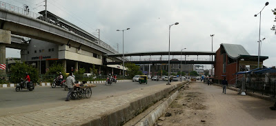
Lakshmi Nagar
Approaching Lakshmi Nagar station

Foot-over-bridges connecting the station to different sides of the road intersection

Station and road intersection

Station and surroundings

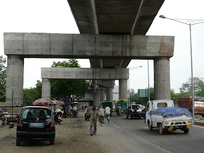
Nirman Vihar
Approaching Nirman Vihar station


Nirman Vihar station with the Lakshmi Nagar Commercial Complex and V3S Mall adjoining


This is the station/area that made me realize how conceptions of distance are changing because of the metro. I've only driven by the Lakshmi Nagar Commerial Complex a few times, and that too not for many years now, but to me it seemed really far and a long drive away. With the metro, it's now just a few stops away from the heart of Delhi, and with the expanding system over the years will become easily accessible from all parts of the city.
Similarly, with the opening of the Gurgaon metro line, a trip to/from Gurgaon already seems like a much less daunting task. Access to different parts of the city will, both conceptually and literally, become much easier, and just as in cities like London and New York, any particular location will be just a metro ride away.
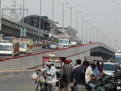
Preet Vihar
Preet Vihar station and adjoining commercial complex


Formerly residential area around the station turning commercial

From these photographs, the nexus between commercialization of neighborhoods and the metro is quite evident. Metro stations were from the beginning planned close to commercial areas, and the areas around many stations are becoming increasingly commercialized, whether they were so before or not. At this Preet Vihar station, buildings that were clearly residential are changing in their nature, and new construction is also much more commercial.
The story through much of Delhi is the same, and the expectation is that the areas around metro stations will become hubs of commercial activity, with residential areas a little distance away. Increased commercialization of the locations around metro stations has always been one of the strategies for revenue generation by the metro, and it seems to be succeeding. This will likely be one of the main ways that metro will alter the built landscape of Delhi in the short to medium term.
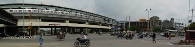
Anand Vihar
This terminal (for now) metro station interchanges with the Anand Vihar ISBT (Inter State Bus Terminal) and Indian Railways station.
Anand Vihar metro station ...

... close to the ISBT

... as well as the railway station

The same photos are also on flickr.
Yamuna Bank
This is the interchange station between the Noida and Anand Vihar sections of the blue line. Situated on the floodplain of the river Yamuna, it's a bit isolated and distant from the closest formal habitation. Embankments protects the station (and it's adjoining metro depot) from the river when in spate.
Yamuna Bank station to the left and the intersection of Vikas Marg and Link Road to the right


Trains from both Noida and Anand Vihar lines approaching the station

Blue line and Link Road heading towards Noida

Lakshmi Nagar
Approaching Lakshmi Nagar station

Foot-over-bridges connecting the station to different sides of the road intersection

Station and road intersection

Station and surroundings

Nirman Vihar
Approaching Nirman Vihar station


Nirman Vihar station with the Lakshmi Nagar Commercial Complex and V3S Mall adjoining


This is the station/area that made me realize how conceptions of distance are changing because of the metro. I've only driven by the Lakshmi Nagar Commerial Complex a few times, and that too not for many years now, but to me it seemed really far and a long drive away. With the metro, it's now just a few stops away from the heart of Delhi, and with the expanding system over the years will become easily accessible from all parts of the city.
Similarly, with the opening of the Gurgaon metro line, a trip to/from Gurgaon already seems like a much less daunting task. Access to different parts of the city will, both conceptually and literally, become much easier, and just as in cities like London and New York, any particular location will be just a metro ride away.
Preet Vihar
Preet Vihar station and adjoining commercial complex


Formerly residential area around the station turning commercial

From these photographs, the nexus between commercialization of neighborhoods and the metro is quite evident. Metro stations were from the beginning planned close to commercial areas, and the areas around many stations are becoming increasingly commercialized, whether they were so before or not. At this Preet Vihar station, buildings that were clearly residential are changing in their nature, and new construction is also much more commercial.
The story through much of Delhi is the same, and the expectation is that the areas around metro stations will become hubs of commercial activity, with residential areas a little distance away. Increased commercialization of the locations around metro stations has always been one of the strategies for revenue generation by the metro, and it seems to be succeeding. This will likely be one of the main ways that metro will alter the built landscape of Delhi in the short to medium term.
Anand Vihar
This terminal (for now) metro station interchanges with the Anand Vihar ISBT (Inter State Bus Terminal) and Indian Railways station.
Anand Vihar metro station ...

... close to the ISBT

... as well as the railway station

Friday, September 03, 2010
On and Around the Delhi Metro: Green Line
I thought I'd finish exploring and photographing Delhi Metro's existing lines before the (entire, for Phase 2) Yellow and Violet lines open, but of course this post goes out on the day the yellow line extension becomes operational! In any case, here are photos from the far flung (at least from where I live) Green Line, which turns out to be a very interesting line to visit.
Heading almost due west on Rohtak Road like an outstretched tentacle out of "inner" Delhi, the green line reaches Mundka via Nangloi. After it crosses the Outer Ring Road, the scenery seems to progressively change from that of Delhi to that of small-town Haryana, and the road becomes lined with rows of small concrete-box shops with their steel shutters up, or small-scale industrial buildings. By the time the metro crosses Nangloi, we could easily be passing through a small town in Haryana rather than Delhi.
I guess Delhi the idea (in all it's craziness and multifariousness) still has to reach many parts of Delhi the state! This statement is surprising even to me, because there is so much of "not-Delhi" even in the heart of Delhi, and yet places like Mundka do not feel like other parts of the city. I guess what this means is that places like Mundka have not had even a touch of Delhi brought to them yet, even though they are well within Delhi state.
Here's a link to the images below at my green line flickr set. Clicking on the images here enlarges them for full effect.
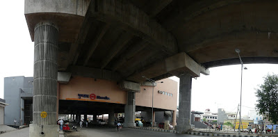
Inderlok
Currently the green line starts at the Inderlok station, where it interchanges with the Red Line at it's eastern-most point.
Panoramas of Inderlok station, with it's mall to the left. Green line platforms are to the right

The green line side of Inderlok station
Soon after leaving Inderlok station, the green line passes uncomfortably close to houses at Tulsi Nagar


Note the barrier on the metro line at the point nearest to the buildings


Shivaji Park


Paschim Vihar West
Metro station alongside residences

Metro station as visible from the nearby residential colony

Peeragarhi
Metro line crossing the outer ring road at Peeragarhi

Udyog Vihar


Surajmal Stadium
Rohtak Road below metro line at Surajmal Stadium station
Looking towards Surajmal Stadium station from Nangloi

Nangloi
Nangloi station and flyover

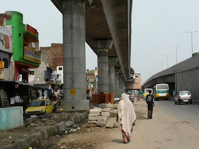
Buildings demolished for the metro line at Nangloi
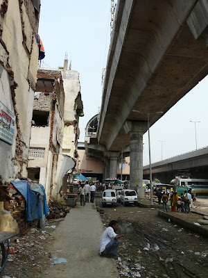

This image is a composite of two photographs so the perspective is a bit askew, but it shows the metro line and an inside street

Looking towards Nangloi RS metro station from Nangloi

Rajdhani Park
This is where things really begin to look like Haryana!

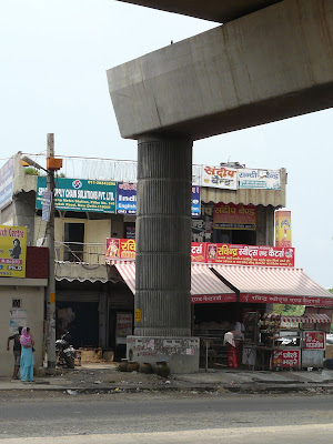
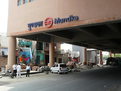
Mundka
Mundka station - the current terminal station for the green line. Haryana continues all around the metro station/line!


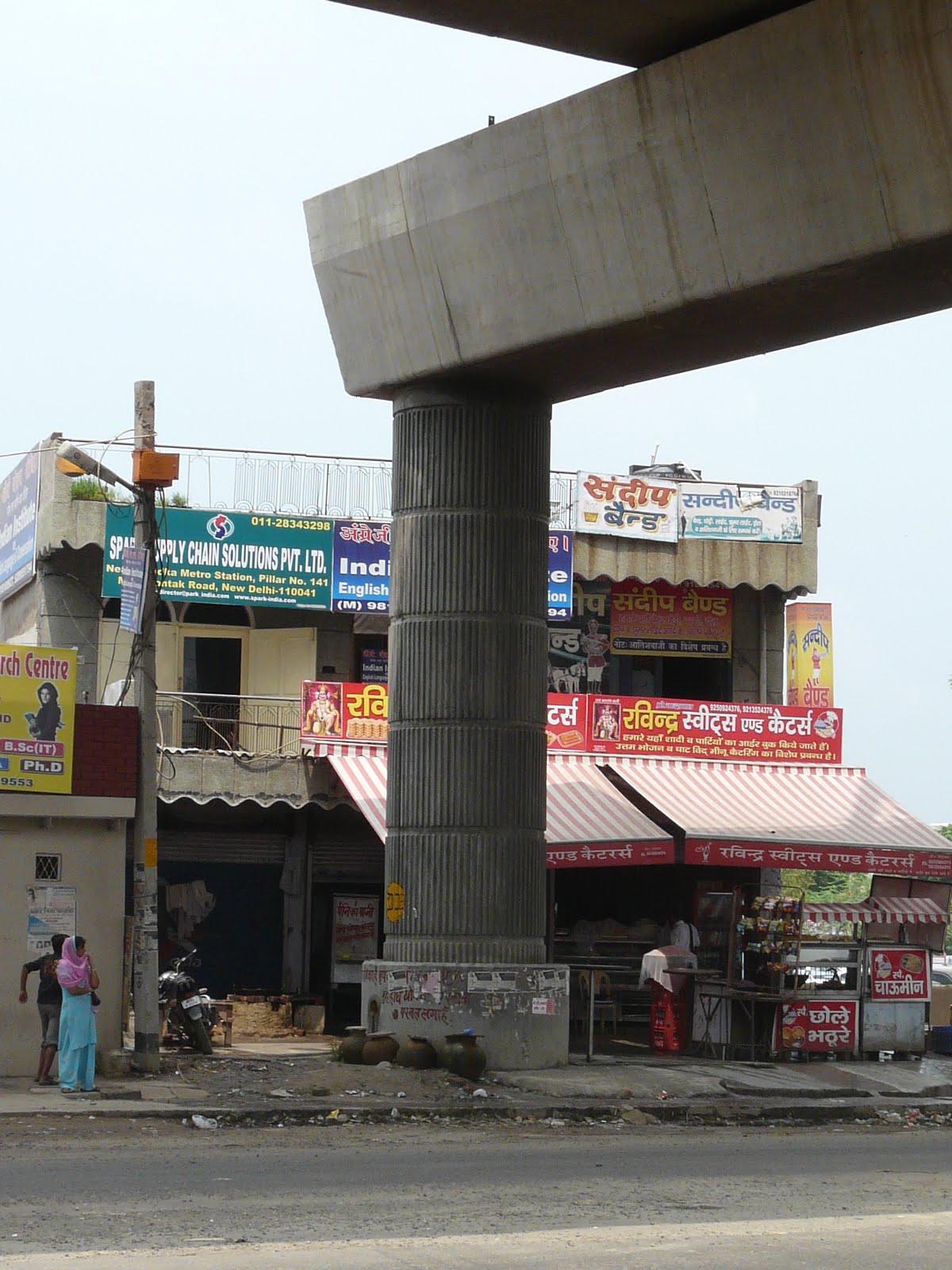
A metro pillar almost trampling a sweets shop
Mundka station panoramas from the parking lot


Rohtak Road under Mundka station

Demolished buildings adjacent to Mundka station

Heading almost due west on Rohtak Road like an outstretched tentacle out of "inner" Delhi, the green line reaches Mundka via Nangloi. After it crosses the Outer Ring Road, the scenery seems to progressively change from that of Delhi to that of small-town Haryana, and the road becomes lined with rows of small concrete-box shops with their steel shutters up, or small-scale industrial buildings. By the time the metro crosses Nangloi, we could easily be passing through a small town in Haryana rather than Delhi.
I guess Delhi the idea (in all it's craziness and multifariousness) still has to reach many parts of Delhi the state! This statement is surprising even to me, because there is so much of "not-Delhi" even in the heart of Delhi, and yet places like Mundka do not feel like other parts of the city. I guess what this means is that places like Mundka have not had even a touch of Delhi brought to them yet, even though they are well within Delhi state.
Here's a link to the images below at my green line flickr set. Clicking on the images here enlarges them for full effect.
Inderlok
Currently the green line starts at the Inderlok station, where it interchanges with the Red Line at it's eastern-most point.
Panoramas of Inderlok station, with it's mall to the left. Green line platforms are to the right


The green line side of Inderlok station

Soon after leaving Inderlok station, the green line passes uncomfortably close to houses at Tulsi Nagar


Note the barrier on the metro line at the point nearest to the buildings


Shivaji Park


Paschim Vihar West
Metro station alongside residences

Metro station as visible from the nearby residential colony

Peeragarhi
Metro line crossing the outer ring road at Peeragarhi

Udyog Vihar


Surajmal Stadium
Rohtak Road below metro line at Surajmal Stadium station

Looking towards Surajmal Stadium station from Nangloi
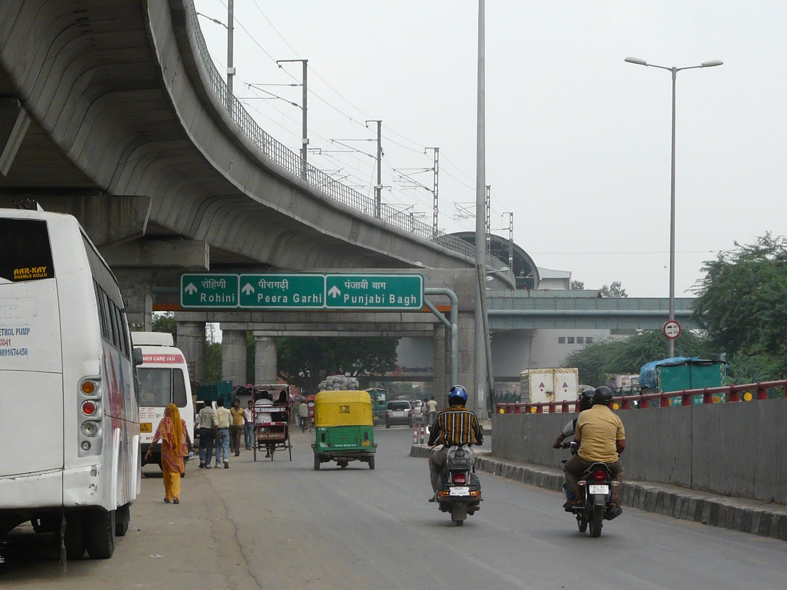
Nangloi
Nangloi station and flyover


Buildings demolished for the metro line at Nangloi


This image is a composite of two photographs so the perspective is a bit askew, but it shows the metro line and an inside street

Looking towards Nangloi RS metro station from Nangloi

Rajdhani Park
This is where things really begin to look like Haryana!

Mundka
Mundka station - the current terminal station for the green line. Haryana continues all around the metro station/line!


A metro pillar almost trampling a sweets shop
Mundka station panoramas from the parking lot


Rohtak Road under Mundka station


Demolished buildings adjacent to Mundka station


Subscribe to:
Posts (Atom)